


The Khafre Revelation: What's Really Happening Beneath the Giza Plateau?
My investigation into viral claims about massive underground structures beneath the Khafre Pyramid: tracing sources, examining evidence, and the full English translation of the Italian press release.

March 24, 2025
Contents
Ancient Mysteries, Modern Questions: A Personal Journey
For nearly 35 years, I've found myself drawn to questions about our planet's ancient past—particularly the possibility that Earth's true history might be far more complex and astonishing than conventional narratives suggest. This journey began in earnest when I first encountered Graham Hancock's "Fingerprints of the Gods" shortly after its publication in 1995, a book that dared to challenge the comfortable assumption that our modern civilization represents the apex of human achievement. Hancock later strengthened his case with 2017's "Magicians of the Gods," further documenting evidence for sophisticated ancient civilizations that were nearly erased from our collective memory by cataclysmic events at the end of the last ice age. If these topics interest you, I highly recommend both books.

What if, instead, we are rediscovering rather than pioneering? What if the ancient megaliths scattered across our planet—from Göbekli Tepe to Puma Punku to the Great Pyramid—aren't merely impressive feats of "primitive" engineering but the weathered remnants of civilizations that possessed knowledge we're only beginning to reclaim? The water erosion patterns on the Sphinx that geologist Robert Schoch has dated to thousands of years before conventional Egyptian chronology; the precise astronomical alignments with the Orion constellation as it appeared not 4,500 but perhaps 12,000 years ago; the mathematical precision built into these structures that seems to encode universal constants—these anomalies have always suggested to me that we're missing crucial chapters of our human story.
The psychic Edgar Cayce famously predicted that a "Hall of Records" would eventually be discovered beneath the Sphinx, containing the historical and spiritual records of a lost civilization. While mainstream archaeology has dismissed such notions, I've remained open to the possibility that the Giza plateau might indeed harbor secrets beyond our current understanding.
That's why when news began circulating about alleged discoveries beneath the Khafre Pyramid, I felt compelled to investigate. Beyond the sensationalism and dismissive debunking, what's really happening? Let's dive in.
The Claims Go Viral
Something extraordinary is allegedly hiding beneath one of humanity's most iconic monuments—at least according to a viral story that's been sweeping across social media over the past week. Claims of vast underground structures beneath the Khafre (pronounced "kah-fray") Pyramid at Giza have ignited both wonder and skepticism across the internet, but sorting fact from speculation has proven surprisingly difficult.
As the story exploded online, I found myself caught in a digital detective hunt, trying to trace these extraordinary claims back to their source. What I discovered was a fascinating case study in how information spreads in our digital age—and a reminder that even in 2025, our understanding of ancient monuments remains far from complete.
The story that caught fire across platforms like TikTok, X, and Facebook describes an Italian-Scottish research team discovering something remarkable beneath the middle pyramid at Giza:
Five structures at the base of the Khafre Pyramid connected by geometric pathways
Eight cylindrical vertical shafts or "wells" descending deep underground
These shafts, allegedly surrounded by spiral pathways, extending to depths of about 648 meters
Two large cubic structures (approximately 80 meters per side) at that depth
Potentially up to two kilometers of tunnels beneath the Giza Plateau
If true, this would represent one of the most significant archaeological discoveries in modern history, fundamentally changing our understanding of ancient Egyptian capabilities and possibly the timeline of pyramid construction itself.
Tracing the Source
After an extensive search for the original announcement, I hit an unexpected roadblock: there wasn't a standard academic press release or publication. Instead, the information appeared to have first emerged through a Facebook post by a researcher named Trevor Grassi.
This unusual path to public knowledge was my first red flag. Most legitimate archaeological discoveries are announced through academic journals or formal institutional channels. But as I dug deeper, the story became more intriguing.
I managed to find an interview (here) between content creator Jahannah James and Trevor Grassi that shed light on how this information reached the public. According to Grassi, he received the research abstract directly from the research team before anyone else and was given permission to share it.
"They sent me this document by email on Saturday morning," Grassi told James. "I was the first person to read it. And I imagine that this was being given to every one of the 900 plus attendees at the conference who would all be sharing it that day... But as it turned out, I was the only one."
Grassi explained that he's been in contact with the research team, particularly with researchers named Corrado Malanga, Filippo Biondi, and Armando Mey, having followed their previous work on the Great Pyramid. He describes himself as someone who has long been interested in "the Giza Underworld," having worked with other researchers including William Brown and Richard Gabriel on related investigations.
The Primary Source Emerges
Following this breadcrumb trail eventually led me to what appears to be the primary source: footage of an Italian press conference, titled "El mistero di Giza conferenza stampa ufficiale" (The Mystery of Giza Official Press Conference). While the conference itself reportedly took place around March 15th/16th, 2025, video documentation only became available on YouTube on March 23rd. The full transcript, translated to English is available at the end of this article. The research team, led by Nicole Ciccolo, has also established an official Facebook page where they've begun sharing information directly.

In this press conference, Nicole Ciccolo introduces herself as the communications manager for the research project called "CERF." She presents the team, including Professor Corrado Malanga (described as a researcher and field leader), Engineer Filippo Biondi (a specialist in SAR technology), and Dr. Armando Mey (an Egyptology expert).
Malanga then takes the stage to explain their findings, which align with the claims that had been circulating. He describes using SAR (Synthetic Aperture Radar) technology mounted on satellites 680 km above Earth to effectively "see through" the solid stone of the pyramids by converting photonic signals into phononic ones—essentially transforming light into sound.
"As you know, photons, light, stops when it hits matter, but sound doesn't," Malanga explains in the press conference. "Granite has a sound velocity of about 4,000 meters per second... if we manage to transform light into sound, what will appear is that granite is more transparent than glass."

The Technology: Revolutionary or Questionable?
The technology described is both the most intriguing and most questionable aspect of these claims. According to both Grassi and the press conference, this approach combines Synthetic Aperture Radar (SAR) with what they call "Doppler tomography."
SAR is indeed a legitimate remote sensing technology used by organizations like NASA for mapping terrain. However, its ability to penetrate hundreds of meters of solid rock—as claimed by this team—goes far beyond its conventional capabilities.
According to Grassi, Biondi "created a new type of software, basically capable of interpreting this data that's being given out by the company that provides this, they give out that satellite data of the S-A-R signals. And Filippo developed this software to be able to interpret it in order to use it on these sites."
One significant advantage of this technology, if it works as claimed, would be the ability to research the pyramids without physical access—a point emphasized by Malanga in the press conference.
"This is an innovative technology that allows looking inside ancient monuments without going there, without moving a stone, thus preserving what is good, without altering its form and structure," he stated.
Previous Work and Context
This isn't the first time this research team has made bold claims. In 2022, Malanga and Biondi published a paper titled "Synthetic Aperture Radar Doppler Tomography Reveals Details of Undiscovered High-Resolution Internal Structure of the Great Pyramid of Giza."
That paper reportedly identified previously unknown structures within the Great Pyramid of Khufu, though Grassi clarifies that the current findings about Khafre are completely separate from the 2022 paper.
"What we have is this short abstract," Grassi explained. "They give us the few images everyone's been sharing, a little bit of text, but they're promising to go a lot deeper on it."
What makes this research approach potentially revolutionary is how it circumvents one of the biggest obstacles to alternative research at Giza: the Egyptian government's notoriously tight control over archaeological access. For decades, researchers seeking to investigate hypotheses that challenge the official narrative about the pyramids' age, purpose, or construction have faced systematic barriers.
The Egyptian Ministry of Antiquities exercises strict authority over who can conduct research at these sites, what methodologies can be employed, and perhaps most significantly, what findings can be published. Many researchers have reported having permits denied, access restricted, or excavations shut down when their discoveries appeared to challenge conventional Egyptian chronology.
This gatekeeping has effectively maintained the status quo narrative about ancient Egypt, making it exceedingly difficult for alternative theories to gain the empirical foundation they need for serious consideration. Even well-credentialed academics have found themselves stonewalled when their research threatened to upend established timelines.
What's potentially groundbreaking about the SAR technology employed by Malanga and Biondi is that it requires no physical access to the site whatsoever. As Malanga explained during the press conference, "We did it from home, without the need for a camera, which needs to place a photographic plate under the material, so you have to go there personally."
In Grassi's words: "This is 100% no on-site access needed, no permits needed, no media censorship needed. They're completely independent team doing this without even having to set foot in Giza."
If verified, this technology could fundamentally change how ancient sites are studied worldwide, potentially unlocking secrets that have remained hidden not just because of physical inaccessibility, but because of institutional barriers to investigation.
Timeline Implications
Perhaps the most controversial aspect of these claims is the suggestion that these structures might predate conventional historical timelines for pyramid construction.
During the press conference, Malanga referenced evidence of sea salt deposits in the Khufu Pyramid as potential indicators of flooding corresponding to climate events approximately 13,500 years ago, suggesting the structures may have been built before this period.
"We must begin to think that perhaps the real Giza plateau didn't see the light 4,500 years ago, but much earlier," he stated.
Such claims align with alternative theories that have long suggested the pyramids might be much older than the conventional dating of around 4,500 years ago—a position that remains far outside mainstream archaeological consensus.
The Skepticism
Not surprisingly, these extraordinary claims have been met with substantial skepticism from the scientific community and fact-checkers alike.
The fact-checking site Snopes quickly labeled the story "false," citing "no credible evidence" to support the claims. Their article, published on March 21, came after the conference reportedly took place on March 15-16, but two days before the video footage became publicly available on March 23rd. This timing suggests they reached their conclusion without access to the full primary source material. Additionally, dismissing claims as "false" when they lack sufficient evidence—rather than "unverified"—reflects the kind of confirmation bias that sometimes plagues fact-checking organizations eager to maintain consensus narratives.
That said, there are legitimate reasons for skepticism. Professor Lawrence Conyers told the Daily Mail that while small structures such as shafts and chambers might exist beneath the pyramids, the idea of a vast underground city is "a huge exaggeration." He questioned whether SAR technology could actually detect structures at the claimed depths, noting that its effectiveness typically diminishes significantly beyond a few meters in solid geological formations.
Critics have also pointed out that some images circulating with these claims appear to have been generated using AI, further muddying the waters.
What Comes Next?
According to both Grassi and the press conference, a full presentation of their findings, including technical details and potentially a formal written report, should be released within days or weeks through Nicole Ciccolo's YouTube channel.
"The official press conference is going to be released on her channel within the next week, it sounds like," Grassi told James. "They don't want to release all these videos with a bousy YouTube subtitles. They want to get a good English translation on it."
This upcoming material may provide the rigor and evidence missing from current discussions. Grassi suggests the presentation will include demonstrations of their technology's effectiveness by showing how it can accurately detect known structures, which would provide a crucial validation of their methodology.
"The proof of the method is the most important thing here," Grassi explained. "If they can show that they can scan a chamber we already know of and show that they can accurately describe its shape with that imagery, then we know that the method works."
The Bigger Picture
What makes this story fascinating, regardless of the ultimate veracity of the claims, is how it highlights the tension between established archaeological orthodoxy and emerging technologies that might challenge conventional wisdom.
The Egyptian government has long been cautious, even restrictive, about archaeological research that could challenge established narratives about the pyramids. If this technology works as claimed—allowing researchers to essentially bypass the need for physical access and governmental permissions—it could represent a paradigm shift in how ancient sites are studied.
As Grassi put it: "This will allow anyone in the world to actually sense underground cities across the planet. And I know at least five or six in Egypt alone, underground cities that are interconnected with tunnels."
Key Points from the Italian Press Conference

For those who don't have time to review the complete transcript (included at the end of this article), here are the essential claims made during the Italian press conference:
The Technology: The team used Synthetic Aperture Radar (SAR) from satellites approximately 680km above Earth, combined with a method called "Doppler tomography." This technique allegedly converts photonic (light) signals into phononic (sound) signals, allowing them to "see through" solid stone structures.
The Claimed Structures:
Five "cell" structures at the base of the Khafre Pyramid, connected by pathways
Eight vertical shafts or "wells," each surrounded by what appears to be spiral pathways
These shafts descend to a depth of 648 meters
At that depth, two large cubic structures measuring approximately 80 meters per side
Additional features potentially extending to depths of around 1,200 meters
Function Hypotheses: Professor Malanga suggested some of these structures may have served structural purposes, helping to stabilize the pyramid on the sand. However, he also indicated the vertical shafts might have served as ventilation ducts or for other technological purposes not yet understood.
Timeline Implications: The researchers referenced evidence of sea salt deposits in the Khufu Pyramid, suggesting flooding events approximately 13,500 years ago. Malanga explicitly challenged the conventional dating of the pyramids: "We must begin to think that perhaps the real Giza plateau didn't see the light 4,500 years ago, but much earlier."
Verification Plans: The team expressed their intention to scan the entire Giza Plateau and suggested that physical excavation would eventually be necessary to confirm their findings.
Data Sources: According to Malanga, their research used freely available satellite data from Capella Space and Umbra Space, processed through proprietary software developed by Filippo Biondi.
The researchers stated they would release more comprehensive documentation of their methodology and findings in future presentations.

A Measured Response
I believe the appropriate stance here is neither uncritical acceptance nor dismissive skepticism, but rather cautious interest. The claims are extraordinary and would require extraordinary evidence—evidence that has been promised but not yet fully delivered.
The research team appears to have legitimate academic credentials, has published previous peer-reviewed work, and has now presented their findings at what appears to be a real conference. However, the unusual path by which this information reached the public, the limited technical details currently available, and the extraordinary nature of the claims all warrant a healthy dose of skepticism.
What we need now is not premature judgment, but careful assessment of the forthcoming presentation and, ideally, independent verification by other researchers using similar or different methodologies.
I'll be following this story closely and will update as new information emerges. Until then, the mystery beneath the Khafre Pyramid remains exactly that—a mystery awaiting further illumination.
March 15th Press Release Transcript in English
El mistero di Giza conferenza stampa ufficiale / The Mystery of Giza: Official Press Conference
Nicole Ciccolo (00:07 - 01:43)
Good afternoon everyone, I'm Nicole Ciccolo, head of communications for the research project called the CERF project. We welcome all accredited Italian press in attendance and all press connected remotely. This is a special press conference to exclusively unveil the results of an absolutely innovative and revolutionary study made possible by the union of a team of researchers who have combined their specific historical-archaeological, scientific, and technological expertise, in particular Professor Corrado Malanga, researcher and field leader of the research project, Engineer Filippo Biondi, specialist in SAR technology, and Dr. Armando Mey, expert in Egyptology. Thanks to SAR technology, or synthetic aperture radar, combined with the new methodology of Doppler tomography, the research group present here has made a series of unprecedented discoveries located beneath the Giza plateau. This technological innovation consists of converting photonic radar information into phononic signals. This would allow exploration of structures buried deep beneath the Earth's surface.
Corrado Malanga (01:44 - 25:30)
To talk about the research we have done. It's innovative research that actually started several years ago, when we began working on the Khufu pyramid, with a "busto," as it's called by experts. From that perspective, we began writing scientific papers and books that talked about what we found with synthetic aperture radar. Synthetic aperture radar is a technique that uses a radar positioned about 680 km above Sweden, orbiting around the planet, that transforms photonic signals into phononic signals, transforming light into sound, into vibration. Everything we can see is therefore a sound image of the things we're looking at. This technique allows us to look inside things. As you know, photons, light, stops when it hits matter, but sound doesn't. Granite has a sound velocity of about 4,000 meters per second, water 1,400 meters, air 340 meters per second. So if we manage to transform light into sound, what will appear is that granite is more transparent than glass. This allows us to see inside ancient monuments, like the three [structures] on the Giza plateau, without intruding.
Looking more closely at the structure of these spots - you see two of them, but in reality there are five, two in front, two behind and one in the middle - these spots are similar to the same spots we recorded in one particular spot in the Khufu pyramid. It's a cell, a structure that we had essentially already seen in the pyramid we had analyzed before. There are 5 of these structures. Tomorrow in the plenary conference we will show how we arrived at these results. Why? Because with radar we can do different tomographies looking at the scene from multiple points of view and thus build a three-dimensional image, perfectly reconstructing stone by stone everything we see. A single tomography is not enough, just this image would not be enough to arrive at the solution to the problem, which we will help you understand with the construction of a three-dimensional model.
This is an image taken from another point of view. You must always have the same objects positioned from a different angle, and the awareness of these images must enter into us. This can only be done by looking at these images for hours and hours, going back to look at old tomographies, looking at new ones again, trying to identify each structure in a three-dimensional way.
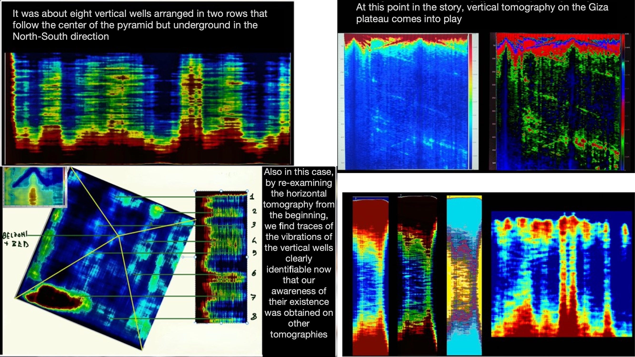
At this point we could build, finally, a three-dimensional model with our research, and we immediately realize - tomorrow we will realize much better because we will show piece by piece how we arrived at these results - that in the Khafre pyramid, which until yesterday Egyptologists said contained nothing, essentially an empty mountain of stone, there are a lot of things. There are 5 cells, 5 placed in a certain position connected to each other by what are likely paths that could actually be corridors. But what we see is that below this structure there are eight vertical poles surrounded by something that resembles a kind of, to use the term, spiral staircase. You see them here from another angle, from another point of view. You see them here again from yet another point of view. Look how much stuff is in there, how many paths can be taken.
There are two rooms in particular, one you see large on the right behind and the other on the left a little smaller at the bottom, which appear in the different tomographies that are definitely something that resembles rooms. Look how it appears before us. And these vertical wells that descend to a certain distance, depth. These vertical wells, as we can see them, from the tomographies appeared very, very clear to what depth this stuff goes. The attempt was to understand this.
You see, we've put in a kind of floor that simulates a water path, because indeed below a certain height of the zero level, let's say, of the pyramid, below there is water. Below the water path there's still stuff, and we go down until we find two structures of this kind that seem, when you look at them for the first time you can't understand what they are. They are actually two boxes, two large giant boxes that we'll discover are about 80 meters on each side in dimensions - two boxes 80 meters on each side.
It's not a phenomenon of pareidolia, as one might imagine, but it's the computer itself that tells us look, they're made like this in boxes, and the computer, with its analyses, with the help of artificial intelligence, reconstructs these two boxes, as you see here, into which four of the tubes that go from top to bottom enter each box. We are at a depth of 648 meters, only at this level, 648 meters.
Let's look at how the tubes appeared in our tomography. The tubes that you see how they're made here, there are eight of them, they are, let's say, arranged in two rows at the center of the long side of the pyramid, and you can see clearly, they're surrounded by something that looks like a kind of spiral staircase going down. This spiral staircase we have reconstructed essentially like this. You see? They are two large boxes into which in each box 8 plus descend into water, up to 648 meters, 4 on one side and 4 on the other.
We are at 648 meters, after that what happens? We needed, so we realized that when looking with this technique, the synthetic aperture radar, these things, not only had we found a lot of stuff in the Khafre pyramid that no one had ever seen before, but moving away a bit with the vision we had seen that there was stuff underneath, and so we had to move even further away.
And in a tomography that tomorrow we will see piece by piece, you can see inside, in the middle of this gigantic tomography, you see the Khafre pyramid at the top. On the left, hidden by the tomography's gray tones, is the small pyramid, which is the small pyramid of the Giza plateau, while actually on the right, invisible, is the Khufu pyramid. You must keep in mind that when we make a tomography, we cut a cake. This cake has been cut in half of the Khafre pyramid, and the resulting photographic plate, since it has the vibration information, not only picks up all the pixels of all the points that are inside the vibration of the plate, but everything in front and everything behind, thus building images that initially are difficult to understand, but that afterwards allow you to understand something fundamental.
Look, let's take just the central part of this tomography, and what we see is that under the central triangle that represents the two sides of the Khafre pyramid, at about 640 meters, there is this square box, this luminous plane that contains the two boxes we showed you before, where the channels that go down are also glimpsed, which here are only intuited because I showed them to you in the previous tomography.
The problem is, but there's still more stuff underneath, it goes down for more than 600 meters, and this allows us to understand that underneath there is a world, a world made up of many things. For example, here below, we're below the plateau, there's a world, and all this luminous stuff here, what is it? All this luminous stuff that vibrates. When we go to make - tomorrow we'll show enlargements - we'll discover that underneath there is a real city, in quotation marks. We are, in terms of depth, about 1,200 meters deep.
How is this calculated? We know that a pixel is x centimeters long, so it's enough to take the number of pixels provided by the computer and we know exactly what we're looking at. Tomorrow we'll also show how the human eye would see these things if it were technically placed on the satellite. I remind you that we used two satellites, not just one, so the two satellites give us completely coherent responses, so anything that could be a sound reflection, we know how to identify it perfectly, because a sound reflection we see on one satellite and not on the other, because the other satellite is somewhere else and therefore sees things in a completely different way.
Another thing should be emphasized. In our research, the two satellites we used, which are Capella Spenis and Umbra Spenis, provide us with the data for free. Anyone can retrieve this data, just go to the website of these two operators and download the data. So this research didn't cost anything. I say this because compared to other methodologies, these other methodologies can be used to look inside the pyramids, like the muonic methodology. Muons, which are particles that fill the universe, irradiate the pyramids. If I put a camera with a photographic plate for muons under the pyramid, I can see how the photographic plate is impressed. A camera for muons costs 1 million 800 thousand euros. It takes 8 months to take a photo. In this context, 10, 12, 15 university institutes around the world were involved with a project called ScanPyramid, which employs 30 people working on it, and therefore quite a long time.
We instead did it from home, without the need for a camera, which, you must keep in mind, needs to be, to place a photographic plate under the material, so you have to go there personally. The problem instead is that we solve it by looking at everything from above, making everything transparent. Stone, granite, I repeat, is more transparent than glass from this point of view.
Basically, while our research lasts a year, a few months, basically the time to verify all the dozens and dozens of photographs taken by multiple satellites, the machine time needed to perform all the Fourier transforms, Cerosi, all these things, it's certainly not the animals, the money, the technology, the people that are necessary to discover a tenth of what we discover with this technology. So this is an innovative technology that allows looking inside ancient monuments without going there, without moving a stone, thus preserving what is good, without altering its form and structure.
At this point there are a whole series of issues that we'll see better tomorrow, because tomorrow we'll follow a path as if everyone had participated in this research and everyone piece by piece had understood every type of stone of the thing we have studied. You can see well. Well, the problem is, so this research, in this context, at this moment, what does it produce as a partial result, because it's obviously not finished yet? The result is this: There are things. See, this research is not to be proven, it's not that you have to wait for other types of work or other scientists who can declare it true, because they are photographs. I photograph the Tower of Pisa and there's no need for another 500 people to photograph the Tower of Pisa to say the Tower of Pisa exists. So this research, just as it is, provides that these data are real.
But what does this mean? It means that someone built something 1,200 meters deep in Egypt. Do we want to believe that it was still the ancient Egyptians? Well, if we want to ask, let's believe it with the final h [note: referring to "Egizi" vs "Egizj" spelling], but the problem is that these are the questions we now have to answer. Tomorrow we'll just show things as they are and we'll send the people who come to this conference home asking them to answer - to make their own hypotheses about what we've found because what we've found we've found, but who built it, when they built it, why they built it, what it was for, these are answers that we will not give tomorrow, but that we should and will have the duty to give in the coming meetings, in the coming conferences.
In the meantime, the need to carry forward this study is evident. Why? Because history seems to need to be rewritten, and this will indeed be the program that we set for ourselves because the Giza plateau needs to be completely scanned to see exactly what's down there, and everything that now appears as luminous spots will soon have a more precise form, and at that point, whoever is in charge will have to somehow become aware of the fact that it's time to go and see, by digging, what's underneath.
So, as far as we know, these natural cavities would have very precise forms, and tomographies that show geometry that totally excludes the possibility that these are natural. Consider, for example, these wells. These wells have this kind of, let's call it in quotation marks, spiral staircase, which wraps around these wells. The brightness of this luminous path has the characteristic of having been reconstructed by computer. And it's not always the same brightness, because the radar considers these wells as if they were made of glass, that is, it sees both the front and back, and when this luminous thing turns around, turns to the other side, its luminous frequency, that is, its vibration, is modified and is modified with three different degrees of brightness, making us understand something fundamental: that these wells are actually tubes, that is, inside there is movement, and they are all the same, and it would be very unlikely that this is something that was made by life. It's clear that at this point the need to go and see in person, therefore to move some stones, is fundamental, because only by looking inside will we discover what's inside. It's like opening an Easter egg. We've discovered the Easter egg, let's go and see the surprise. But we know there's already a surprise.
As you can see, I'm showing you the 3D construction, you can understand exactly how the 3D model reconstructs exactly what we see from a tomography. Now tomorrow I'll show you 10 tomographies, from 10 different points of view where these wells can be clearly seen in all their essence. Consider that these wells have a diameter of about 10-12 meters and a depth of at least 648 meters. One thing to note is that some of these structures serve to support the pyramid because we've done static calculations and we've seen that the Khafre pyramid weighs a lot and to hold it up you need a base because otherwise it would sink into the sand. The calculations show that essentially over thousands of years these structures have sunk by more or less half a meter. The builders evidently foresaw that you cannot build a pyramid on sand, and so underneath it's necessary to build pillars that somehow reach down to the granite at the bottom and that support a plate that tomorrow exists...
[interrupted by speaker in audience]
Audience 1 (25:31 - 25:55)**
If there are structures 1,200 meters underground, if I remember correctly, 12,000 years ago the water was 120 meters lower, so we are still in another historical era, because we're basically 20 km below?
Corrado Malanga (25:55 - 27:59)
Fundamentally yes. Indeed, who says that the pyramids were built 1,500 years before Christ? This is a question mark that is becoming increasingly... this hypothesis is becoming increasingly less credible. This allows us to say and to make a number of trivial observations. So, if the pyramids were actually built as they say, we must remember that 4,500, 1,600 years ago, 2,500 years ago, precisely, the ancient Egyptians didn't have the wheel, didn't have writing, didn't know how to write, didn't have the lever, didn't know how to cut stone, and how would they have managed to build something that goes down to 1,200 meters underground, besides all the plateau of Giza, how did they move the stones, each of these stones of the Khufu pyramid because it was covered in the other. There are some who say, no, just put more men, if 13 men aren't enough I'll put 20, and we should make these people understand that putting 20 men around a stone that is 3 meters long is perhaps not easy. But we should make these people understand that they need to understand, and this is the most difficult thing. The last three years of pandemic have made us understand this, for example, that it's not such a simple thing. So we must necessarily begin to think that perhaps the real Giza plateau didn't see the light 4,500 years ago, but much earlier.
Audience 2 (27:59 - 28:27)
I wanted to ask what led you to believe that these underground structures correspond to the Halls of Amenti? If you've considered the hypothesis that all this stuff is a big something that has to do with chemical actions or with the possibility of extracting materials from the subsoil, from an industrial complex.
Corrado Malanga (28:35 - 33:45)
Our idea starts from an observation. History is historicist, meaning whoever writes history videos is always someone who finds it convenient to give an idea of what can make people think that history is myth is not historicist. Myth represents the reality of facts in a single frame. In myth is written the past, present and future in that instant. Myth must be taken into consideration, it must be re-evaluated, and in myth it is written there are somewhere halls called the Halls of Amenti which contain, some say books, some others more distant, this we don't know, but where there's smoke there's always a bit of fire. This is the idea that made us think that these large structures were something that had to do with that stuff that is written in the book.
Then, at this moment, we believe that these eight wells, which from recent tomographies we have discovered are also under the Khufu pyramid and which at the time of the analysis we hadn't seen because obviously we didn't have the awareness so we didn't go to look with the right eye under the Khufu pyramid, but now - and tomorrow we will show you - we have realized that by doing a series of tomographies from a distance, also under the other two pyramids. And it's exactly right if these columns are needed to maintain the stability of these pyramids, they were also needed under the Khufu pyramid and under the Mycerinus pyramid, necessarily.
But right now we have the idea that they not only served to create stability for these large monuments, but now there are at least two or maybe three other purposes that I'm not telling for now because they would be based on little, but that clearly when we will have the possibility to better understand or to go in person to see this stuff, then perhaps we will understand that back then there was a technology that we still don't have.
Our idea is substantially linked to the fact that the ancients, whoever they were, had a strong awareness and consciousness of what the physics of phonons is and not of photons, that is, of the electromagnetic field. We are fixated on photons, on light, Maxwell, good, these people according to my modest point of view knew how to work on vibrations. So much so that in the first works, that is, in the work published on Remote Sensing, we say this, attributing to the structure of the pyramid what is today the functioning of an infrasonic machine that, by moving with the wind, produced through those cells properly placed - you have seen five here, placed practically in parallel - produced a certain vibration that cured the pharaoh or whoever. And here too, not only in the Egyptian myth, but in the ancient myths from all parts of the world, it is written how the ancients used sound to heal.
Clearly if we want to consider myth a joke, then we can do that. But faced with the calculations we have made, we have seen that perhaps there are numbers that have a particular precision. People think that the ancient Egyptians didn't know the Pythagorean theorem. The Pythagorean theorem was not only known to the ancient Egyptians, but they built a pyramid with it because if you don't know the Pythagorean theorem, the pyramid cannot be built because it will turn out badly, and when one does the right calculations with measurements, one discovers that the Khafre pyramid, like the Khufu pyramid, are built not only on 3.14159 and not on 3.16 as someone says, an approximation of the Pythagorean theorem, but also on 1.618033, which is the Golden Section. In a precise way, this substantially means that the mathematics of the ancient builders of these monuments included a series of awareness and consciousness that we today believe the ancient Egyptians didn't have and that instead seems to be used, that is, there's the arch, there's the first...
Audience 2 (33:47 - 34:18)
May I continue? I ask this because some of the internal structures of the pyramids look very much like reactors, like reaction chambers, not so much like something that would be used at a human level, that is, for people. The idea I got from being inside is perhaps something that served a fluid, I don't know, but not so much to create...
Corrado Malanga (34:21 - 35:10)
Well, the important thing is to make hypotheses, because central research must be approached by making hypotheses. Because if you don't make hypotheses, you don't know what to research. But the hypotheses must be varied by measurements. So, right now, we are not able to say what all this structure is for except by making hypotheses. But we are able to say with absolute certainty that these structures are there and that they are not casual and that someone therefore put them there. From there, then we can start to make all the investigations we want, but that stuff is there and someone put it there.
Presentation Team 1 (35:10 - 36:27)
The scientific method is important, because the scientific method is based on the repeatability of the experiment, so from my point of view there is no alternative research, research is research, so there isn't, I think that research, there is no alternative research, and I look for it here from my point of view. So what we have applied is the -200. We took this for different manufacturing, that is, they built different factories for me, two different companies. We have Italian laboratories for both Capella Speses and the other Umbra. The same things came out, alright regarding the measurement of the depth. In fact, I remind you that we took a bit of courage to provide the data we did the impossible we measured the level cut here, cut there ask in artificial intelligence just in case...
Corrado Malanga (36:28 - 36:33)
We had artificial intelligence redo it, which gave the same results as ours.
Presentation Team 1 (36:34 - 36:44)
And so I am... There's no certainty as a scientist, I can't say no, that's how it is, just weighing a study. But...
Corrado Malanga (36:44 - 36:49)
That's how it is at 99%. That's how it is, there...
Presentation Team 1 (36:49 - 37:24)
would be verified products that descend to a depth of a pilot of 2, a pilot of 4, we have to see well, the force is there, the force of 2, a pilot of 4, with interconnected boxes and further down there are large bands that can be seen, we measure them and so this will be the future. As you've seen there are many sculptures that present agrorectangular singularities...
Presentation Team 1 (37:30 - 37:51)
Nature is very good, nature is excellent at generating natural cavities, the fact of the agrorectangular seems to me something that could be done by fortunate, that is, by people who come to calculate the length, the height, the...
Corrado Malanga (37:59 - 38:03)
What is seen from my view is all the same material that is always seen to be the same.
Presentation Team 1 (38:03 - 38:41)
Well to do this I cannot answer you, because to do this, the largest is the so-called burst appearance. It can be done, but it seems good to me. So you can make memories at different frequencies, create a database, the so-called dictionary of frequencies as the material varies and then give the answer. As you see, the seriousness of view that has been saved in a type of research is the one where you could not go there is no blue I cannot tell you...
Corrado Malanga (38:43 - 38:47)
However, it is solid where it shines, it is the sound...
Presentation Team 1 (38:47 - 39:33)
sound where it shines a little less because there is the background, the so-called contrast material, maybe there's water, alright, it's less bright or also there's darkness, so where there's something bright and especially this is something bright, excuse me if I succeed, as you can see from the drafts it's bright to reach all the way to the top because we take the data of economic scopes from the surface it must be connected to the surface otherwise you don't know because if it's isolated if there was vibration it remains confined down there and we from above don't hear any compass.
Presentation Team 2 (39:35 - 42:59)
Certainly this research, the results we are obtaining are extremely important because they also confirm the pre-existence of a city that lived on this planet in remote times. You know that crazy time, I proposed a vision, let's say, of the dating of the Giza planet due to a series of documents that are considered of little interest but which with the progress of this research are assuming an increasingly marked significance. I refer for example to the Emerald Tablet, because this is to answer Thomas, who asked a specific question about why myths, so I see also on this question.
But also for example the chronology of the royal canon, the myths that are told in the Book of the Dead, in short, so there are a whole series of different sources that suggest a pre-existence that is in a way determined in 36,400 which is also in line with the maximum of myths. And so, I mean, this work we're doing is absolutely revealed because it goes to establish a whole series of conditions that until today seemed to be, how to say, not very active.
Regarding the consideration of the association of this discovery with the city of friends [possibly "City of Amenti"], in addition to what has also been precisely specified, there are some elements that are emerging from the reconstruction of what we are identifying under the surface, which seem to be consistent with some descriptions we find in this sense. First I make a reference to the tablets of Signor Dino, where there are precise references to these wells that go in proper units, which were built in the gesture of speaking of the ends of light, we don't know who they are, but the objective fact of the presence of these wells that go in proper units remains. Just as the boxes we were talking about earlier are described in these temples as halls with a size like space, precisely to emphasize how enormous these halls were.
Plus there's a further reference to the Book of the Dead of Fyzio, in particular to chapter 149, where there's a description of these halls not extremely precise, in fact it talks about 14 residences but only some of these are discrete, which seem to assume, let's say, from the reconstruction, precise connotations that leave us, how to say, give us a certainty that we are targeting knowledge. My hypothesis, which however needs to be verified from a historical point of view...
Corrado Malanga (43:00 - 45:29)
is that about 13,500 years ago, following a cataclysmic event of which almost all the information is available today, which has then been reproduced for scientific works, substantially measured, 3,500 years ago, roughly, we have what we call the "Younger Dryas," that is, an object or multiple objects hit our planet, also modifying the terrestrial axis setting. In that context, some scholars maintain that the water of the Giza area rose by more than 100 meters in height. And we find traces of this because inside the Khufu pyramid, two and a half centimeters of sea salt have been found visiting all the walls. Sea salt that was removed by Tum, by Chiawas, when he cleaned the pyramid. It's evident that therefore seawater entered the pyramid and then evaporated neatly because otherwise the process would have been freed of a certain gold.
This makes me think that 13,500 years ago the pyramid, if it was functioning, would have stopped functioning because afterwards it would have been unusable anyway. So the idea I've formed is that this stuff was used before the universal [possibly referring to the cataclysm]. Afterwards who remained there? The survivors, let's say. A few hundred years later, returning to that place, also to the Giza Plateau, they restored, as indeed it's written somewhere, the Khufu pyramid, they didn't build it, but they restored it, and then however I don't know what they did with it, and what use they made of it, certainly it wasn't the use of those who built it, who...
Presentation Team 1 (45:30 - 48:33)
Spatial resolution is scientifically defined as a distance, and it's the minimum distance at which two objects can be distinguished separately. That is, I move away, I have two objects, at a certain point I see two, then I no longer see two, I see one. So the wavelength, what is the wavelength of the physical phenomenon that I use to investigate something to get a photograph? The wavelength, I have that wavelength for a distance, so they are both in the numerator. This makes me understand that the more I increase the distance, the more the spatial resolution degrades; the more I decrease the wavelength, so increase the frequency, the more, well, the resolution increases. Divided by twice the aperture. The aperture is fundamental. The aperture, in cameras, is the opening of the lens. That camera has a higher aperture compared to those in front. Hence we can explain the synthetic aperture radar.
From space from 680 km, to have a spatial resolution, for example super-metric on Earth, doing calculations that you can easily do at home, it comes out that you need to build an antenna for example with a length of 60-70 km, that is, a piece of equipment in space of 70 km, how do you do that? You have used this, let's say, other structure, that human beings can have...
Corrado Malanga (48:34 - 49:22)
with the various factors are devastating. Yes, not so devastating as one might think, we've done an investigation, we've seen that essentially 38 degrees at 6-720 meters distance, and the interesting thing is that these tubes, which we previously thought were columns, are instead ventilation ducts, they can serve as vertical exchange changers, because exchange changers are made like this, they are two doubts, one moment the other, one exits from the retarda and the other enters from the rectum, so it could be that these doubts unite to go and travel what's underneath. Not by chance in ancient texts there is talk of...
Presentation Team 2 (49:22 - 49:29)
these deep wells that bring the light of life. This methodology...
Corrado Malanga (49:30 - 50:29)
that we have applied for these things actually has a hallucinatory potential because it could follow to find water in the desert, it could follow to find oil in the desert, it could follow to find precious metals on the Moon or some hole, perhaps desired, but if there isn't the MiniSAR project that has already somehow made SAR data available for example for the Moon, but why not used? It could be useful to see, or what do I know, submarines of the "enemy" in quotation marks, somewhere. It could in short... So we are beyond the banal hypothesis of looking inside a monument. Certainly it is...
Presentation Team 1 (50:29 - 51:22)
a technology that will allow us, if used well, to free. From my point of view, the applications could be multiple. It seems to me that two days ago there was talk of starting some telluric activity in the Neapolitan area. Here, an activity, an objective according to me step by step, with returning data to humanity and then certainly monitoring volcanoes. So going to check for example the degree of instantaneous activity of ancient volcanoes. There are...
Corrado Malanga (51:22 - 54:47)
vibrations that could disturb us in doing our analyses, and vegetation, for example, produces problems. Because the reading makes the trees move and substantially if one doesn't place in certain conditions of factoring afterwards they end up not seeing anything. That's why we placed ourselves in the best situation, saying in Giza there isn't a conical growth, it does very well, but certainly the ball is complicated, so we will also discover things in areas, such as for example the vitamins of biscuits, and they have this problem of the vegetation that's above. But it's a small thing that we've already given ourselves, but that's another story.
My thought is that mainstream Egyptologists will never change, because one of the characteristics of the human being is equicity [possibly meaning stubbornness or inflexibility]. So, there are many Egyptologists who are essentially human, they've written books, they've had the possibility to put forward theories, and perhaps before dying what do you do? You demonstrate that what they had written was all wrong? Human beings are not very capable at a consciential level of admitting they might have been wrong. I live in another world, I live in the world where consciousness is the important thing, not the length of your department's desk.
In this context, we know and consciousness serves to interpret tomographies because through consciousness we have introduced a fundamental parameter which is the human being's perception of what is in front of them. So in this context, my personal experience is, I have learned in life only when I have failed, that is, only when I have made mistakes, because when one never makes mistakes, one never learns or anyway wouldn't need to learn.
So, from this point of view, I would say to the mainstream Egyptologists, as we have called them, the famous official science, there is no official science, there is science, there are scientists who are a bit more like rabbits and scientists who are a bit less, but it substantially depends on the level of awareness one has, I would say.
What's the probability that a scientist with this mentality, with this type, but the scientist is perhaps a bit if it's turned, a scientistic maybe, a scientist is another thing, that with the truth there is that he changes opinion? We've seen it also lately in the last three years of pandemic, people didn't change their opinion despite having asked a sea of nonsense, so I imagine why? Because changing opinion is like saying "ah but then I was wrong," at the instant in which I say I was wrong but I'm happy to have been wrong in comparison. The majority of human beings say they are not happy to have been wrong, because they think they've made a mistaken point.
Further Information:
Here is the English translation of another announcement that was made prior to the main press release and presentation on March 15/16:
Hello and welcome to the expedition channel of Project KEFRE. This is the second communication stamp in the quality of the responsibility of the area of communication for the research project. I am reading the second communication stamp of Project KEFRE, sent at this hour to the Italian and international press.
Discovery Announcement:
Thanks to the synergy between archaeology and cutting-edge space technology, our research team has been able to uncover an enormous city deep beneath the Giza Plateau, which corresponds to the legendary Amenti. This city is mentioned in ancient texts as a place of universal human knowledge and spiritual transformation.
This extraordinary discovery was made possible through the processing of SAR (Synthetic Aperture Radar) data obtained from Capella Space's satellite. This represents an innovative technological approach for archaeology. The uniqueness of this discovery lies not only in its historical and archaeological significance but also in the method used, which involved very high-resolution azimuthal radar images through particular Spotlight acquisitions with long Doppler intervals, allowing for the extraction of the correct acoustic information.
Technological Innovation:
The satellite data was processed using a revolutionary technique known as Doppler tomography, developed by Professor Filippo Biondi, an international expert in synthetic aperture radar, interferometry, and multi-chromatic tomographic analysis. This method enables three-dimensional reconstructions of underground structures, identifying corridors, chambers, and tunnels up to kilometers deep. These new archaeological findings could rewrite our understanding of the sacred topography of ancient Egypt, providing spatial coordinates of buried and unexplored structures.
Research Team:
The result of this presentation was only possible thanks to the contribution of a multidisciplinary team of international renown:
• Nicole Ciccolo: A forensic professor with over 25 years of experience in civil and criminal analysis, who has collaborated with numerous Italian newspapers and authored significant foreign analyses. Her expertise in decoding ancient manuscripts was crucial for interpreting symbols at the site.
• Professor Filippo Biondi: A specialist in radar technology and satellite imaging with experience at the University of Strathclyde, the Italian Space Agency, and the National Research Council. He is currently one of the world's leading experts in developing SAR data processing algorithms, with applications in space archaeology.
• Dr. Armando Mayne: A historian and Egyptologist specializing in the study of predynastic civilizations. He has conducted field research in Egypt and collaborated with numerous international academic institutes. His theories on the correlation between underground structures and the myth of Zep Tepi have guided the investigations.
• Professor Corrado Malanga: Head of the research project, a chemist, and former researcher at the University of Pisa, with a long career in studying consciousness and phenomena related to the perception of reality. His expertise has allowed the development of new interpretive models for analyzing individual structures.
Future Events and Project Continuation:
• March 15, 2025: A press conference for registered journalists, available both in-person and remotely. Details will be provided in the video description.
• March 16, 2025: An official conference where the research team will present the findings and images processed via Doppler tomography. This event has already sold out due to extraordinary public interest.
In the coming months, Project KEFRE, SAR Technology will continue to work on new tomographic analyses and three-dimensional models of subterranean structures, aiming to reconstruct a complete and precise map of what lies beneath the Giza Plateau. The project will continue its research activities throughout 2025, with all announcements shared through official documentation and scientific publications in online archives available to all interested students.
Conclusion:
This discovery represents an epochal step in understanding ancient Egypt and its relationship with the depths, potentially leading to unprecedented revelations about the civilization that built these infrastructures, including the pyramids, which now appear to be just the tip of the iceberg of a colossal project.
Thank you for your attention.
Source video:
The Researchers


I tried accessing the dataset from umbra.space and contrary to what is in the transcript, yes there is an open data program, but I could not find any on the Giza plateau. Its possible to browse the bucket and dataset but only a few are named and other just have some sort of hash code that you cannot identify. Also in Umbras handbook on the technology at no point there is mention on subterrain data.
What Ive asked myself anyway is how the "transform light into sound" idea would work anyway given the satellite does not have a "sound sensor" for that. Apparently Umbra works in the X-Band "for high resolution surface mapping". For ground penetration you would need much lower frquencies. Also in general Doppler Shift Analysis in SAR is used for velocity mapping (e.g., moving targets) not subsurface scanning. So I would really like to see more on their methodology.
Congrats on an informative and unbiased article.